

Ask for pricing
1240 Sylvia St.
1240 Sylvia St., DeSoto, TX, 75115
4 beds
3 baths
2,759 sqft
All about this rental
Desoto, TX Home
Quick overview
- Type:
- House
- Neighborhood:
- Kentsdale Farm
- ZIP code:
- 75115
- Status:
- Active
- Last checked:
- 1 hour ago
Find your perfect layout
This property is fully occupied.
Perks of living here
Shared spaces & benefits
- Back Yard
Fees & policies
General fees
- Security deposit:
- $3,600
There may be additional unit-specific fees.
Get to know the area
Know your way around
Car-dependent
Walk Score®
No data
Transit Score®
Somewhat bikeable
Bike Score®
The area around 1240 Sylvia St., DeSoto, TX, 75115 is highly car dependent. Few, if any, services and amenities are nearby, making a car essential for running errands. 1240 Sylvia St., DeSoto, TX, 75115 is in a somewhat bikeable area, with minimal cycling infrastructure available for use.
Walkability data provided by Walk Score®
See what’s nearby
Discovery Childrens Academy
Childcare • 9.64 mi
Dallas International University
College • 7.33 mi
University of North Texas - Dallas
College • 7.85 mi
Cedar Valley College
College • 8.03 mi
John G. Mahler Student Center
College • 9.90 mi
Counseling Center
College • 9.96 mi
Dallas Baptist University
College • 9.97 mi
Strickland Building
College • 9.97 mi
DBU Graduate Affairs
College • 9.98 mi
Glenn Heights Park & Ride
Bus
3.78 mi
Desoto Heliport
Airport
4.45 mi
The Crossing Shopping Center
Bus
4.48 mi
Eagles Nest Estates Airport
Airport
4.73 mi
Flameleaf @ Hedge - W - FS
Bus
4.81 mi
Cracker Barrel (DeSoto)
Bus
4.90 mi
Clark @ Cloverglen - S - NS
Bus
4.93 mi
Crescent Medical Center
Bus
4.96 mi
Desoto Heliport
Airport
4.45 mi
Eagles Nest Estates Airport
Airport
4.73 mi
O'Brien Airpark
Airport
6.50 mi
O'Brien Airpark
Airport
6.54 mi
Dallas Executive Airport
Airport
7.62 mi
Mid-Way Regional Airport
Airport
8.37 mi
Ferris Red Oak Municipal Heliport
Airport
9.76 mi
Lancaster Regional Airport
Airport
9.90 mi
Glenn Heights Park & Ride
Bus
3.78 mi
The Crossing Shopping Center
Bus
4.48 mi
Flameleaf @ Hedge - W - FS
Bus
4.81 mi
Cracker Barrel (DeSoto)
Bus
4.90 mi
Clark @ Cloverglen - S - NS
Bus
4.93 mi
Crescent Medical Center
Bus
4.96 mi
Flameleaf @ Sophora - W - NS
Bus
4.96 mi
Flameleaf @ White Ash - W - NS
Bus
5.08 mi
UNT Dallas
Train
7.61 mi
Camp Wisdom
Train
8.76 mi
Ledbetter
Train
9.61 mi
Whataburger
Food
1.29 mi
Nur Cafe
Restaurant
1.72 mi
McDonald's
Food
2.80 mi
Whataburger
Food
2.90 mi
Panda Express
Food
2.91 mi
Starbucks
Restaurant
2.92 mi
Mason's Chicken & Seafood Grill
Food
2.94 mi
Pizza Hut
Restaurant
2.95 mi
Whataburger
Food
1.29 mi
McDonald's
Food
2.80 mi
Whataburger
Food
2.90 mi
Panda Express
Food
2.91 mi
Mason's Chicken & Seafood Grill
Food
2.94 mi
Chick-fil-A
Food
3.07 mi
Jason's Deli
Food
3.29 mi
McDonald's
Food
3.36 mi
Nur Cafe
Restaurant
1.72 mi
Starbucks
Restaurant
2.92 mi
Pizza Hut
Restaurant
2.95 mi
Touchdown Sports Bar & Lounge
Restaurant
3.05 mi
Los Tapatios
Restaurant
3.18 mi
Azteca
Restaurant
3.23 mi
Chili's
Restaurant
3.23 mi
Buffalo Wild Wings
Restaurant
3.28 mi
Walmart Supercenter
Grocery store
1.46 mi
Walmart Neighborhood Market
Grocery store
1.88 mi
Family Dollar
Shopping
2.19 mi
Walmart Neighborhood Market
Grocery store
2.24 mi
ALDI
Grocery store
2.33 mi
Walgreens
Shopping
2.75 mi
ALDI
Grocery store
2.78 mi
Shell
Grocery store
2.81 mi
Walmart Supercenter
Grocery store
1.46 mi
Walmart Neighborhood Market
Grocery store
1.88 mi
Walmart Neighborhood Market
Grocery store
2.24 mi
ALDI
Grocery store
2.33 mi
ALDI
Grocery store
2.78 mi
Shell
Grocery store
2.81 mi
Tom Thumb
Grocery store
2.85 mi
Albertsons
Grocery store
2.96 mi
Family Dollar
Shopping
2.19 mi
Walgreens
Shopping
2.75 mi
Dollar Tree
Shopping
2.92 mi
Total Wine
Shopping
3.06 mi
Music & Arts
Shopping
3.13 mi
Nothing Bundt Cakes
Shopping
3.18 mi
Spec's Wines, Spirits & Finer Foods
Shopping
3.27 mi
Guitar Center
Shopping
3.28 mi
Southwest Baptist Church
Place of worship
1.15 mi
De Soto Seventh Day Adventist Church
Place of worship
1.26 mi
Bank of America
Public service
1.32 mi
City Hospital Emergency Cate Center
Healthcare
1.40 mi
Walmart Pharmacy
Healthcare
1.46 mi
7-Eleven
Automotive
1.46 mi
Chase
Public service
1.54 mi
DeSoto House of Peace
Place of worship
1.72 mi
7-Eleven
Automotive
1.46 mi
Walmart
Automotive
1.91 mi
Walmart
Automotive
2.25 mi
Shell
Automotive
2.81 mi
Tom Thumb
Automotive
2.92 mi
Valero
Automotive
3.02 mi
Prism
Automotive
3.23 mi
Complete Auto Repair
Automotive
3.23 mi
City Hospital Emergency Cate Center
Healthcare
1.40 mi
Walmart Pharmacy
Healthcare
1.46 mi
Walmart Pharmacy
Healthcare
1.87 mi
Walgreens
Healthcare
2.75 mi
Tom Thumb Pharmacy
Healthcare
2.87 mi
Zena Dental
Healthcare
2.95 mi
CVS Pharmacy
Healthcare
2.97 mi
City Hospital Emergency Care Center
Healthcare
3.16 mi
Holiday Inn Express & Suites
Hotel
3.29 mi
Comfort Inn & Suites Cedar Hill Duncanville
Hotel
3.44 mi
Fairfield Inn & Suites Dallas Cedar Hill
Hotel
3.47 mi
La Quinta Inn & Suites
Hotel
4.24 mi
HWY Express Inn & Suites
Hotel
4.38 mi
Scottish Inns
Hotel
4.59 mi
La Quinta Inn & Suites Dallas Duncanville
Hotel
4.65 mi
Motel 6
Hotel
4.71 mi
Century 21
Other
3.45 mi
Steve Corder - State Farm Insurance Agent
Other
5.38 mi
Alecia Francis - State Farm Insurance Agent
Other
5.38 mi
Nationwide - Reggie White Agency
Other
5.43 mi
Dero
Other
6.65 mi
Access Insurance Agency
Other
6.83 mi
McKnight Insurance Services
Other
9.66 mi
Great Clips
Personal care
2.96 mi
Bliss Nail Bar
Personal care
2.96 mi
Next Level Barbershop
Personal care
3.55 mi
Perfect Brow
Personal care
3.57 mi
Perfect Brow Skincare
Personal care
3.57 mi
Ulta Beauty
Personal care
3.57 mi
Natural Look Skin Care
Personal care
3.58 mi
Allure Nail Bar
Personal care
3.62 mi
Tri City Animal Shelter
Pet care
2.64 mi
Petco
Pet care
2.94 mi
Cedar Hill Veterinary Clinic
Pet care
3.18 mi
Gabby's Sanctuary Ark
Pet care
3.77 mi
Rudy's Pawsome Kingdom
Pet care
4.77 mi
Greenbriar Veterinary Hospital
Pet care
5.05 mi
The Animal Care Center
Pet care
5.22 mi
PetSmart
Pet care
5.51 mi
Southwest Baptist Church
Place of worship
1.15 mi
De Soto Seventh Day Adventist Church
Place of worship
1.26 mi
DeSoto House of Peace
Place of worship
1.72 mi
Shiloh Cumberland Presbyterian Church
Place of worship
1.82 mi
DeSoto Christian Church
Place of worship
1.91 mi
De Soto Assembly of God Church
Place of worship
1.96 mi
Dallas First Church of the Nazarene
Place of worship
1.97 mi
First Baptist Church of De Soto
Place of worship
2.07 mi
Bank of America
Public service
1.32 mi
Chase
Public service
1.54 mi
DeSoto Post Office
Public service
2.08 mi
DeSoto Post Office
Public service
2.09 mi
BBVA Compass
Public service
2.29 mi
Southwest Regional Communication Center
Public service
2.79 mi
United States Post Office
Public service
2.85 mi
The UPS Store
Public service
2.96 mi
Eagle Stadium
Sports
1.16 mi
Tiger Stadium
Sports
2.64 mi
Cedar Hill Recreation Center
Entertainment
2.78 mi
Longhorn Stadium
Sports
3.46 mi
Zula B. Wylie Public Library
Entertainment
3.66 mi
Cinemark 14
Entertainment
3.71 mi
Crawford Park Pool
Sports
4.07 mi
International Museum of Cultures
Entertainment
4.07 mi
Cedar Hill Recreation Center
Entertainment
2.78 mi
Zula B. Wylie Public Library
Entertainment
3.66 mi
Cinemark 14
Entertainment
3.71 mi
International Museum of Cultures
Entertainment
4.07 mi
Cinemark Movies 14
Entertainment
4.47 mi
Duncanville Public Library
Entertainment
5.15 mi
Amphitheater
Entertainment
5.19 mi
Duncanville Recreation Center
Entertainment
5.31 mi
Eagle Stadium
Sports
1.16 mi
Tiger Stadium
Sports
2.64 mi
Longhorn Stadium
Sports
3.46 mi
Crawford Park Pool
Sports
4.07 mi
Crawford Park Tennis Court #2
Sports
4.10 mi
Crawford Park Basketball Court #3
Sports
4.11 mi
Crawford Park Tennis Court #1
Sports
4.11 mi
Crawford Park Basketball Court #2
Sports
4.11 mi
Average utility cost in Texas
In Texas, renters typically spend around $456 per month on utilities, with costs ranging from $20 for cable to $170 for electricity, depending on factors like home size, season, and usage.

Electricity
$170
$170

Gas
$81
$81

Water
$65
$65

Sewer
$85
$85

Cable
$20
$20

Internet
$35
$35
Community reviews
How are these reviews collected?
No reviews for this property yet, or for other rentals managed by this company. Be the first to share your story.
Still looking? Here's more!
16
Available now
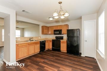
From $1,835 /mo
6118 Veranda Way Dallas, TX 75241 | House for rent
6118 Veranda Way, Dallas, TX, 75241
3 beds
3 baths
1,566 sqft
12
Available now
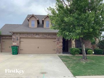
From $3,305 /mo
2224 Abela Drive Waxahachie, TX 75165 | House for rent
2224 Abela Drive, Waxahachie, TX, 75165
4 beds
3 baths
2,993 sqft
FAQs about 1240 Sylvia St.
When was the data on this property last updated?
The information for 1240 Sylvia St. was last updated 1 hour ago.
What floor plan options are available?
At 1240 Sylvia St., there is only one floor plan option, three-plus-bedroom.
Is 1240 Sylvia St. pet-friendly?
Yes, 1240 Sylvia St. is pet-friendly.
In what neighborhood is this property located?
1240 Sylvia St., DeSoto, TX, 75115 is in Kentsdale Farm.
What are some of the most popular house rentals in Kentsdale Farm?
Some of the most popular house rentals in Kentsdale Farm include:
334 Lisa Ln, 8304 Timberbrook Ln, 6118 Veranda Way Dallas, TX 75241, 2224 Abela Drive Waxahachie, TX 75165.
How far is this property from the city center?
1240 Sylvia St. is approximately 22 minutes away by bike from the city center.
How do people usually get around the area?
The area around 1240 Sylvia St., DeSoto, TX, 75115 is highly car dependent. Few, if any, services and amenities are nearby, making a car essential for running errands. 1240 Sylvia St., DeSoto, TX, 75115 is in a somewhat bikeable area, with minimal cycling infrastructure available for use.
What childcare centers are nearby?
There's one childcare center close by, Discovery Childrens Academy.
What colleges are nearby?
Here are some nearby colleges: Dallas International University, University of North Texas - Dallas, Cedar Valley College.
Are there any house rentals around for the same amount?
Here are houses for rent near 1240 Sylvia St., DeSoto, TX, 75115 with similar pricing: 6118 Veranda Way Dallas, TX 75241, 2224 Abela Drive Waxahachie, TX 75165.
Are utilities included in the rent at 1240 Sylvia St.?
Utilities are not part of the rent at 1240 Sylvia St.; tenants are responsible for covering them.
Cast a wider net
Just around the corner
- Houses for rent in Briarwood
- Houses for rent in Mockingbird Hill
- Houses for rent in The Mile Creek Estates
- Houses for rent in Hampton Square Heights
- Houses for rent in Renee Acres
- Houses for rent in Windmill Hill
- Houses for rent in Oakmont
- Houses for rent in Wildwood
- Houses for rent in Hampton Place Estates
- Houses for rent in Green Meadow Estates
- Houses for rent in High Meadows
- Houses for rent in Lynnwood Estates
- Houses for rent in Grimes Park
Close by, worth a look
- Houses for rent in Cedar Hill
- Houses for rent in Duncanville
- Houses for rent in Red Oak
- Houses for rent in Lancaster
- Houses for rent in Midlothian
- Houses for rent in Grand Prairie
- Houses for rent in Waxahachie
- Houses for rent in Mansfield
- Houses for rent in Dallas
- Houses for rent in Arlington
- Houses for rent in Irving
- Houses for rent in Seagoville
- Houses for rent in Alvarado
- Houses for rent in Euless
- Houses for rent in Mesquite
- Houses for rent in Bedford
- Houses for rent in Ennis
- Houses for rent in Burleson
- Houses for rent in Hurst
- Houses for rent in Farmers Branch